
October 05, 2020
Geophysics
Geophysics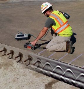 uses specialized non-invasive technologies to measure and identify differences in the physical properties of materials such as pavement, concrete, soil, and rock. Within our Construction Services, Environmental, Energy, Geotechnical and Transportation Business Units, experienced geophysicists and engineers use this geophysical data to supplement and support conventional exploration sampling services and/or to help refine unique site features.
Ground Penetrating Radar (GPR) survey to locate steel reinforcement and embedded steel objects in three-dimensional view.
Traditional exploration services such as drilling, coring, and test pits provide below ground or subsurface information, but only at a few discrete locations on a project site. Engineers and geologists must analyze and interpret these results over wide areas to develop a subsurface model. The subsurface model may not be adequate when budget, site access restrictions, or environmental issues limit traditional exploration methods. Traditional exploration services may also inadequately define subsurface conditions when the object or feature targeted, like an underground storage tank, debris pit, or sinkhole is small relative to the site and exploration spacing. Geophysics provides cost-effective exploration alternatives to supplement or guide traditional methods.
What are the benefits of geophysics?
- Non-destructive: Geophysics can typically be performed without significant disturbance, a consideration for sensitive areas of a site.
- Time-effective: Geophysics can typically be used to evaluate large areas relatively quickly compared to traditional exploration sampling services that require excavation or direct access to the subsurface, which can significantly increase field effort.
- Cost-effective: Time-efficiency and guiding or reducing typical invasive testing through geophysics provides a more comprehensive approach to a project scope while also generally assisting with lowering overall project costs.
- Value: Geophysics provides much more coverage, and hence, more subsurface information across a site than data only obtained from widely spaced discrete points collected through traditional exploration methods.
Ground Penetrating Radar (GPR)
There are many geophysics methods available, and choosing an appropriate technique depends on the site conditions, goals of a project, and experience level of the field and office staff using the methods. That said, Ground Penetrating Radar (GPR) is one of the most versatile geophysical methods available.
The GPR method transmits electromagnetic radio waves into the subsurface from an antenna at a specific frequency, which are then reflected back to a receiver from interfaces between materials with contrasting properties (e.g. concrete/metal, asphalt/stone, sand/clay, etc.). GPR surveys are performed in general accordance with ASTM D6432, ASTM D4748, and ASTM D6087.
GPR can be used in the following applications:
- Asphalt, concrete, and stone thickness evaluations
- Bridge deck condition assessments
- Locating embedded concrete structures (e.g. rebar, conduit, and pre/post-stressed cable, etc.)
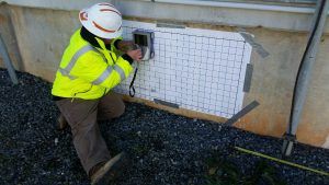
- CMU wall evaluations
- Void/cavity detection and lateral delineation
- Archaeological and cultural resources studies
- Locating buried objects (e.g. USTs, debris, etc.)
- Bedrock and karst exploration
GPR Services: Managing Risk and Bringing Valuable Results
Regardless of the type or size of a project, various subsurface risks exist. Thus, a critical step in any project’s success is to identify potential risks and attempt to mitigate those risks to an acceptable level for the owner, design team, contractor, and end-users. Unknown or poorly defined subsurface conditions often lead to unexpected costs and schedule delays. Even man-made structures such as pavements and steel-reinforced concrete bridges can deteriorate over time, resulting in voids or other anomalies beneath the visible surface. S&ME uses various modern technologies and laboratory testing methods to explore and characterize site subsurface conditions and structures such as those described above. We also apply the engineering analyses, supported by our local knowledge and experience, to serve our clients, and offer cost-effective solutions.
Example GPR Applications
Pavement Structure Thickness and Bridge Decks Evaluations
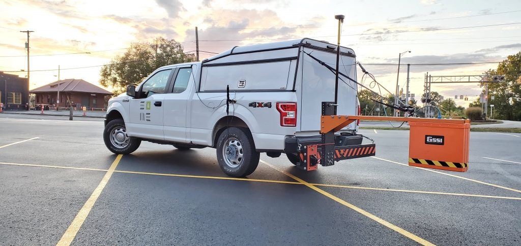
S&ME’s GPR offers a fast and efficient way to collect continuous pavement layer thickness data and bridge deck evaluations at highway speeds.
Our infrastructure in the U.S. is aging and the need to assess and evaluate our existing roads, bridges, and airports is becoming increasingly important. This is where GPR can greatly assist. High-speed GPR services using an air-launched antenna, such as the 2 GHz system we employ at S&ME, can eliminate the need for lane closures and traffic disruptions while evaluating infrastructure-related projects as data can be collected at posted speed limits. For pavement evaluations along roadways, taxiways, and runways, layer thicknesses can be identified and provided as color-coded plots for use in GIS or other user-friendly formats such as a Google Earth file based on the GPS coordinates also collected during a GPR survey. Possible features of interest such as unknown embedded steel reinforcement or buried patches as well as potential voids or saturated areas directly beneath the pavement structure are other infrastructure applications for GPR. For existing bridges, GPR amplitude responses are used to perform statistically derived condition assessments of the embedded steel structures. Color-coded plots of rebar cover depth and potential corrosion areas for evaluated bridges are provided to assist clients such as counties and state DOTs with their inventory assessments
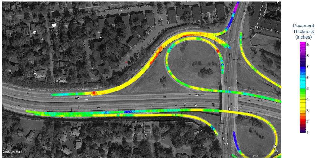
Example color-coded pavement thickness plot along on and off-ramps.
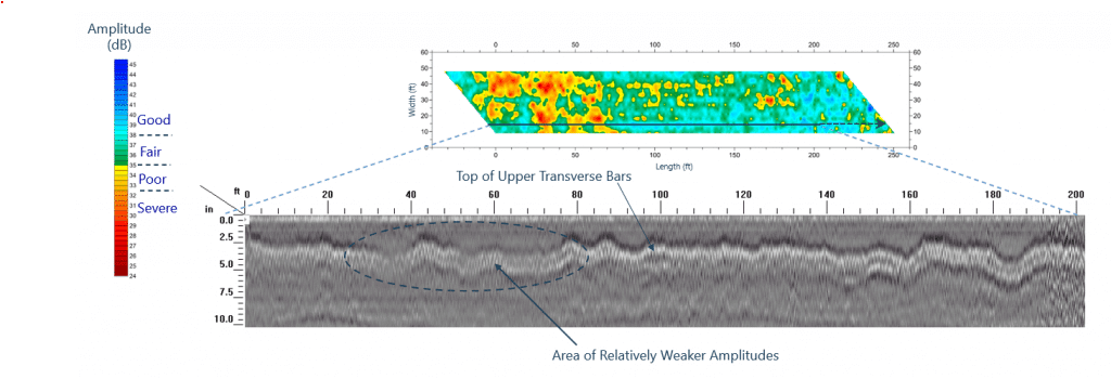
Example color-coded bridge deck embedded reinforcement condition assessment plot with GPR profile highlighting variations in amplitudes associated with possible corrosion.
Concrete Dam Spillway Evaluations
The potential undermining of an existing concrete dam spillway due to erosion and subsequent voids presents a serious hazard not only to the integrity to the dam itself but also the impact on the environment, local economy, and even human life. The GPR method provides an efficient and economical approach for identifying possible issues such as voids located beneath a concrete spillway. Various GPR systems and antenna frequencies can be deployed depending on the size, shape, and even logistical challenges associated with a particular spillway. At S&ME, we have tackled everything from a small residential spillway at a local pond/reservoir to spillways over 250,000 square feet in size in an effort to support local, state, and federal clients with determining the long-term stability of these types of structures. Several evaluated structures even required special rappelling deployment methods of the GPR system due to steep slopes. Depending on the goal and scope of a project, results could be as simple as marking potential voids directly onto the concrete spillway as identified while in the field or as comprehensive as providing CAD/GIS files of identified features based on field measurements and GPS. In addition, dense data collection can utilize 3D processing techniques for even more advanced evaluations for potential subsurface hazards.
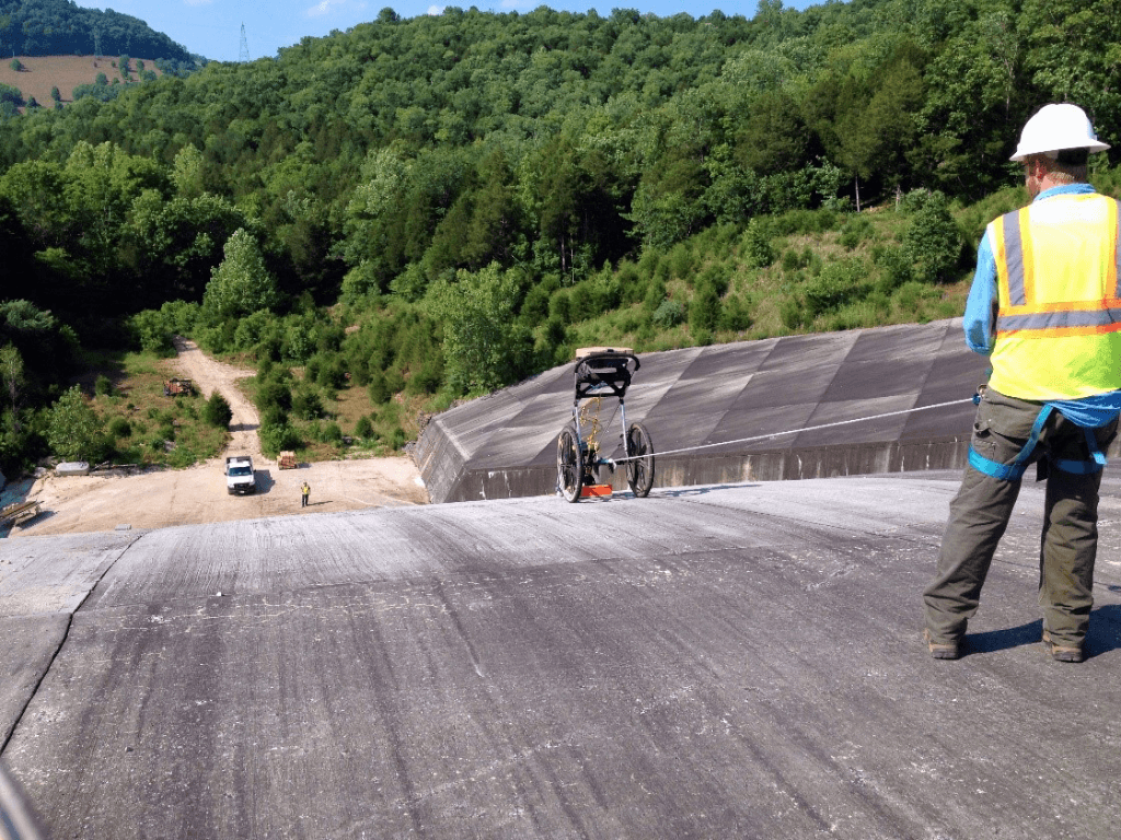
GPR deployment down the face of the spillway using rappelling techniques.
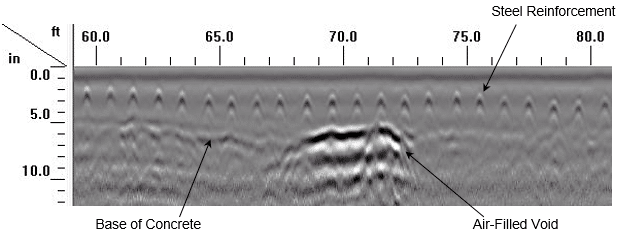
Example GPR profile highlighting an air-filled void identified directly beneath one of concrete panels in the middle of a spillway.